On: Colca Canyon

View of some of the villages in the Colca Canyon.

Last weekend we finally got to do one of the main touristic attractions of Arequipa: hiking the Colca Canyon. We decided to do a three-day/two-night hike, and because we are both SERIOUSLY broke and I speak enough Spanish to understand directions we decided to go without a guide. That being said, I do not plan to go into specific detail about how to independently hike the Colca Canyon. It is pretty easily done with plenty of patience and an intermediate to advanced level of Spanish. It’s definitely better than going with a tour group since you can go at your own pace and stay where you’d like, so I completely suggest to anyone considering heading to the Colca Canyon to grab a friend and save some serious soles by striking out on your own. However, most of my readers (aka my family and some friends) aren’t planning a Colca trip, so the exact details of how to go independently won’t be very necessary.

If anyone came here for step-by-step instructions on how to do an independent trek of the Colca, there are some great resources online that I used. These two sites were really what I went off of, and they also provide links to the maps that we used to get around (although honestly, the maps are basically useless and you’re better off asking locals for directions):

Pachamama Hostel in Cabanaconde: http://www.pachamamahome.com/tours.htm

How to Hike the Colca Canyon, Without a Guide: http://theparallellife.com/2011/11/28/how-to-hike-colca-canyon-without-a-guide/

I will also gives some tips in the story below about some of the mistakes we made and lessons we learned, so hopefully someone can avoid making them! Let’s get started:

Kyle and Traveling Dog.

Day one of our Colca adventure started with us hailing a taxi at 12:30am in Arequipa. We had gone to the busport the day before to ask when the various bus companies left for Cabanaconde, the town nearest to the start of the canyon’s most popular hikes (S17 bus ride on Reyna). Turns out the buses left at either 1am or 8am, and since it’s a six hour ride, we opted with 1am to get an early start and beat some of the canyon’s infamous heat. Upon arriving in Cabanaconde with only three hours’ sleep, I fed a cute street dog some of my breakfast crackers and he followed us for three days. We asked directions to the Mirador de San Miguel at a hostel in Cabanaconde, which according to the above guides is the starting point for a hike down to San Juan de Chuccho. Turns out, it’s not that simple.

Mirador de San Miguel trails.

It took us about forty minutes to find the mirador, since (as with the rest of the country) the Colca Canyon has no way-finding signs. We had to hike out of town, along the main road, and then turn left before the soccer stadium to get to the mirador. Once there, we spent nearly another hour hiking up and down paths that seemed to lead from the mirador to nowhere. It doesn’t help that you can’t see the bottom of the canyon from the top since it’s over twice as deep as the Grand Canyon. Luckily, we saw another backpacking group with a guide walking past the soccer stadium and to a different cliffside. We surreptitiously followed them and found the actual trail, which was way more obvious.

The actual path to San Juan to Chuccho.

Once we were on the right path, it was really hot and an incredibly steep three hour trek downhill. We met a man with two lazy eyes riding a donkey up the path who very kindly told us a safer way to go when we got to the bridge at the bottom of the canyon. Once we got to the bridge, we had to show our boleto turístico that we bought on the bus when we entered Cabanaconde (S70, the cost doubled this year). You need the ticket to get into the villages in the Colca and the Condor lookout. We took the much less steep path to the right after crossing the river, and hiked back up to San Juan de Chuccho were we slept the entire rest of the day at our hostel called Posada de Roy.

Rooms at Posada de Roy.

I HIGHLY recommend that hostel!! It has the only private bathrooms in town, and quite possibly in the canyon. You do have to deal with bugs and spiders, but all the buildings in the canyon are made from adobe with thatch roofs, so that is to be expected. It was S20/person for a room and S10/person/meal which were delicious! The family was so kind, and spending the evening by candlelight since there was no electricity in town was something I had never had to do before. Smart tip: bring a flashlight, we forgot one which made getting around in the dark pretty hard.

The path gets very narrow and scary at points.

The next morning we did not get going as early as we should have since we opted to sleep in until 8:30am and get moving around 9:30. Terrible idea! It was so very hot in the canyon by that time, and it only got hotter. The wife of the owner of our hostel gave me very long and specific directions to get to our next destination, and I am so glad she did! The path forks a lot, and it would be very easy to waste hours going in the wrong direction. When in doubt, take the path with the most hikers’ footprints. Unfortunately, we went during the off-season and almost no one was hiking the valley in early November so we had to mainly go with directions and guesswork.

As you can see from the first picture, we had to start the hike by going straight uphill to the next town of Coshñirwa. We were sweating and miserable by the time we got there an hour later, but luckily the path flattens out and the road to Malata (not pictured but it’s to the left of Coshñirwa) is pretty straightforward. From there, we had to hike all the way back down to the bottom of the canyon to cross another bridge over the river and then back up to our final Colca destination: Sangalle, aka The Oasis. All in all, day two took about three and a half hours to hike.

A view of Sangalle before hiking down to the river.

Once you get to the Oasis, if you take the lower path you walk straight through a hostel with two pools called Oasis Paraíso which I read was no good according to the blog I linked to above. We tried to explore around, but it is really hard to find the other hostels since there is no signage and so many trees in the Oasis. We finally found one after continuing to hike to the left (when facing Cabanaconde) and then down a flight of stone stairs to Paraíso Lodge, which was pretty nice. It had shared bathrooms, and the doors of the entire place were made of bamboo sticks which made it a little uncomfortable when people walked past the bathrooms and could look in and see you.

Paraíso Lodge, view of the main building.

Paraíso Lodge cost the same as most of the hostels in the valley at S10/person for a room and S10/person/meal. It also offers a nice pool and a place to wash your laundry by hand. We were the only people at the hostel in San Juan de Chuccho, but there were many other groups with guides in Sangalle. We met a nice group that consisted of a few Germans, a guy our age from Austria, and a nice lady from France. It was fun to talk to other travelers and hear the conversation going in so many languages at once. Another tip: bring water purification tablets since water is S5 for a personal bottle and S10 for a 2.5 liter bottle. It was even S10 for a beer. Ouch!

The next morning we were smarter and started our hike out of the Colca Canyon at 5:30am. Even then, the hike is just wretched and you will sweat an insane amount and possibly want to lay down and cry. It took us nearly four hours to finally reach the top of the canyon, and it the weather was heating up at the end of it, even that early in the morning.

This is the worst part of the trails: stone stairs.

A big part of the trails down into the canyon and back up again look like this, and it’s the worst! Your muscles are already so exhausted, and having to lift your legs up at such uneven intervals and so constantly makes them give out even more. It got really disheartening at times to not be able to see the top, but we succeeded and it was a great feeling to finally be out of the canyon and head back into town. It wasn’t easy to get back though since we couldn’t find a clear path and ended up trekking through corn fields and hopping fences in people’s backyards.

We got back into Cabanaconde around 9:30am, bought tickets to return to Arequipa for 11:30am (S17 through Señor de los Milagros) and bought breakfast at a restaurant in the Plaza de Armas (S5). Final tip: do not take Milagros bus company, we stopped in the middle of nowhere and none of the drivers would tell us why. They locked the passengers in the bus cab and refused to answer anyone’s questions. We finally realized the bus must have broken down because they were pouring giant 2.5 liter bottles of water somewhere under the hood. After maybe 40 minutes, the drivers got back in the bus and drove off with the engine sounding very sick. The guy who was driving also decided it was better for the dying bus if he drove on the left side of the road and ignored the screams and poundings of the passengers yelling at him to drive in the right lane. I could constantly see an approaching car, bus, or big rig coming right for us, and then the driver would swerve out of the way at the last minute then go straight back into the left lane. It was a pretty terrifying two hour journey back to Arequipa, but we made it safe and sound with potentially a few more grey hairs from the experience.

In general, we are really glad we got to hike the Colca Canyon. It was exhausting and the return journey was quite scary, but now we know we can hike straight up a mountainside twice as deep as the Grand Canyon, so that’s pretty cool.

On: Last Few Weeks in Peru

It’s that time—the time where I only have just over one week left in this country. Six weeks ago, I couldn’t wait to get home, but now that it’s actually coming up so soon, I am getting hit with bouts of weepy nostalgia. I will be happy to be home to be with my family, friends, and doggies, but I know I will still look back on Peru as an amazing experience and one I feel so blessed to have been able to do. That being said, let me catch you up on what we have been doing these last few weeks:

Kyle and I went as tourists, a costume most people didn’t get.

First off, we celebrated an arequipeño  Halloween. We decided not to spend any of our extremely limited funds on costumes, so we dug into our pile of souvenirs and things that had been gifted to us by our students and dressed as the ultimate tourists for Halloween. We even wore our hiking boots. We quickly realized the joke did not land since all the Peruvians just thought we were normal tourists. Because European tourists actually dress like that on the streets, every single day.

The group that we went out with (sort of).

In order from L to R: some woman I have never met before in my life, Kyle, our boss Christian (as a nun), our co-worker and fellow American Jeremy, our boss’ wife and secretary at the school Pilar, and two other people I don’t know. We were supposed to go with this group to some exclusive night club, which they told us they were leaving for in fifteen minutes. We sat down at a table and Christian ordered us a round, during which the other group immediately left. The five of us were happy to do our own thing for the evening, so it worked out. We decided to just meander to a different club in downtown and watch the Peruvians get silly.

Calle San Francisco, packed to the brim.

We wound our way up the street from La Catedral, and smacked straight into a wall of people that only got thicker as we tried to push our way up Calle San Francisco where most of the discotecas are. It was crazy! It was more packed than a summer’s day at Disneyland! People seemed to have resigned themselves to not getting into the already overflowing discotecas and just started drinking in the streets. We managed to eek into a nice discoteca where I snapped this pic of the streets below.

So how do Peruvians spend Halloween? They take their kids out trick-or-treating for an hour or so, then spend it like they do every other holiday: getting heavily sozzled. We did not partake in the revelry too heavily since we were waking up early the next morning to see another aspect of arequipeña culture, las peleas de toros, the bull fights.

Bulls literally head-to-head.

Now, as anyone who knows me knows, I am not okay with any form of animal cruelty: dog fights, cock fights, matador matches, etc. However, I read about Arequipan bull-fighting and thought it sounded like the fairest of matches when it comes to animal fights. How it works is that they parade a fertile cow around, and then put two bulls in a ring who lock horns and wrestle for the right to get with the lady. The fight is over once one bull runs away; there is no bloodshed and no cattle prods, only calming pats on the head for the loser and hugs for the victor. If the two bulls don’t want to fight, then the owners lead them out of the ring and the match ends in a tie. I was happy to see such decent treatment of the animals, but I know my Spaniard friends who had gone to a match a few weeks earlier were a little disappointed not to see any deaths. What very different cultures!

None of the photos are zoomed in, that is really as close as we were sitting and really as shoddy security as the wooden walls held up by branches provided the crowd. The most exciting moment is when a bull got loose from its owners and ran bellowing through the crowd standing right in front of us. No one got hurt, and now I know if you have an angry bull running straight for you, just wave a hat, sweatshirt, or even your arms in its face and odds are it will just run on and leave you alone. Click on the video below to see a bit of what the fights look like…

Kyle and I had been wanting to go see the fights since the first time we came to Arequipa, but they are not well-advertised and since they are generally held in the rural outskirts of the city, most people don’t know when they are. I had to go to three tourist information desks to finally find someone willing to look it up for me.

Quequeña home with Jesus watching over the town.


To get to where the bullfights were held (in the tiny little town of Quequeña) was an adventure in and of itself. Kyle, Jeremy, and I hopped on a oh-so-hellish combi where we were lucky to get seats, but unlucky to be at rear-end level when one of the large mass of people standing in front of us farted in a windowless, hour-long journey (which cost S1). Ugh. We got dropped off where we were supposed to wait for another combi to take us onward, but after waiting half an hour, we managed to hail a solitary taxi and just split the cost of that (S20 total for another forty minute ride). He took us straight to the ring (S15 admission) exactly when the fights were scheduled to start at 1pm. They didn’t start until 2:30pm, which is late even for Peruvian time.

We were the only white people in the crowd, and our risk of sunburn was increasing with every passing minute in the blazing heat. Once the first match began, we checked our brochures and saw there were 11 scheduled for that day’s games. We only made through like six before our skin couldn’t handle anymore, so we went out of the stadium to find a way home. As it turned out, all the taxi and combi drivers were inside watching the matches so odds were we would have several hours to kill before we could get home. We explored the town a little bit, and the surrounding fields, and then were lucked out and hailed a passing bus that took us all the way back to Arequipa for just S2.

Quequeña’s church in the main plaza.

On Saturday (November 3rd) we finally got to embark on a trip we had been hoping to do even before leaving for Peru, but assumed we couldn’t due to lack of money. We got to hike into the Colca Canyon, the world’s second deepest canyon, for three hot days and two sore nights. I’ll go into that more in my next post, since it is going to take me a little while to sort through 166 photos and three days worth of information. So stay tuned and I’ll be back with more experiences from Peru!

On: Puno

The day after our island-hopping tour, we parted ways with our Spaniard/Lithuanian/Peruvian friends who were continuing on to La Paz, Bolivia. We would have joined in, but people from the States have to pay $130 just to cross the border (thank you, Evo Morales!), so we stayed behind in Puno. The initial idea was to stay a third night on Isla Amantaní with a local family and learn about their living culture, but another four hours’ boat ride to get there did not seem too likely to happen when I was still a bit dizzy from the altitude.

We ended up deciding to head back to Arequipa that night and just explore around Puno a bit during the day. We started with a simple trek up to the Mirador del Condor (Condor Lookout) which can be done in an hour or so from the main square. It was a short hike, but at over 12,500 ft above sea level, it was an exhausting one all the same. We ended up just hanging out in markets and wandering the town instead of hiking any more that day.

View of the Mirador del Condor from the Plaza de Armas, Puno.

We checked out of our hostel, left our backpacks in the luggage storage, and headed down the street to the main square. From there, we just meandered generally upwards through neighborhoods, asking for occasional help and not understanding the directions the kind puneños were giving us.

Stairs up to the Mirador del Condor.

We finally came across the blue staircase we could see from the Plaza de Armas, which took a really long time to hike up. The streets are narrow and steep along the hillsides, so I was already out of breath before we even got here. We had to stop every few flights of stairs to fend of headaches and dizziness. Whew!

Metal condor.

Once at the top, the view was really amazing. You could also climb up to the top of the condor statue (that clanks threateningly in the wind as its metal feathers bend and bang against each other), but the platform was filled with amorous teenage Peruvian couples blasting several songs at once from their cell phone’s radios. We opted to stay on the ground.

View of Puno and Lake Titicaca.

Above is one of the striking views of Puno afforded by the somewhat miserably long and steep hike up to the Mirador del Condor. The contrast between the bustling, anthill life in Puno as compared to the (well-touristed) relatively tranquil life on the lake was something to be seen, and something that I am glad we took the time and money to go check out.

On: Lake Titicaca

A hand-made Uros reed boat.

We finished up our last day of work on Friday, which means our Peruvian life is quickly coming to an end! Early Saturday morning, Kyle and I raced to catch our bus to Puno where we would be meeting another Brittany teacher, Ieva, and some other friends. Apparently Puno is the second-most touristed city in Peru after Cusco, but not because of the charms of the city itself. People come to Puno from all over the world to see the beauty of the world’s highest navigable lake (and biggest lake in South America): Lake Titicaca.

Giggle-inducing names aside, Lake Titicaca truly is worth a visit. We spent the first day resting and acclimating to the extreme altitude of Puno at 12,566 ft. We booked a tour for the next morning to visit the islands of Uros and Taquile for S35 (less than $14), which was only S5 more than if we explored the islands using public transportation instead of with a guide. Normally, Kyle and I are all about independent travel because it’s cheaper and you don’t have to wander in a big group, but in this case we went with the convenience of not having to worry about how we were going to get to and from the islands.

Islas Uros, the floating islands.

The next morning, the six of us that traveled up together from Arequipa barely made it out of our hostel in time to catch the 6:45am van that would take us to the dock where we would begin our tour. We were loaded onto a boat with people from all over the world (our friends from Spain and Lithuania, me and Kyle from the States, and then people from Singapore, England, Ireland, Japan, Italy, Germany, Canada, Australia, Ecuador, and one person from Peru) and set off for the half hour boat ride to Islas Uros, the floating islands of Lake Titicaca.

Learning how the islands are built.

After being ushered onto one of the floating islands of Uros, we were greeted by the Aymara-speaking people of Uros and given a demonstration of how the islands are built by the president of that particular island. Totora reeds, which the homes, boats, and islands themselves are made out of, grow in abundance in Lake Titicaca. Once they reach a certain maturity, the roots float up to the top of the lake and make a cork-like substance (the dirt brick in the picture) that the forms the foundation of the island. Wooden stakes are driven into the cork, which is usually only a foot or two thick, and then nylon rope is tied around the posts to keep the island together. In antiquity, ropes made of woven grass were used to tie the cork together, but nylon rope has made the islands much more stable and secure for the islanders. Totora reeds are then piled on top of the island in a cross-hatch pattern, with a new layer replaced as a layer underneath rots away. The houses, also built of totora, are then placed on top. Totora is also eaten regularly on Uros, and we were each given a reed to peel like a banana and chew on the root of to try. It tasted a bit like styrofoam to me, but I suppose you get used to the flavor since islanders of all ages were eating it.

We were then invited in groups of three into the islanders’ homes to get an idea of how they live. The men typically work on the mainland during the day while the women stay home to watch the kids and cook in special ovens on the island. Both men and women make beautiful handicrafts to sell to the visiting tourists. The women embroider gorgeous textiles and and the men make mobiles of totora reeds of Uros families as well as model boats and paint typical scenes from Uros on pieces of cloth. You can find such handicrafts on the mainland at much cheaper prices, but they are generally of much poorer quality. It’s better to fork out for a trinket or two, since tourism is often the families’ only source of income.

Tourists can pay S10 to take a ride in a totora boat.

Uros society has a long history since the Uros people are one of the oldest, if not the oldest tribe in South America. Hundreds of years ago, they chose to leave the mainland and create these floating islands in an effort to escape the warring tribes that surrounded Lake Titicaca at the time. They have been living that way ever since, although they don’t entirely eschew modern technology. Most Uros use motorboats to get around and there are even solar panels on the island to heat water tanks. The house that we visited was entirely made of totora reeds with a bed also made of reeds, but they also had a car battery powering a tiny television on the floor and a light strip on the ceiling. The Uros culture has survived because of, as well as for, tourism, but its heritage is starting to fade. The last Uros language-speaking person died in the 1970s, and now the community speaks Aymara and Spanish.

Me at one of the several arches on Isla Taquile.

Most of our group paid S10 to take a totora reed boat to one of the neighboring Uros islands, but we took the motorboat and met them at a larger island with a tourist market and a place where you could get your passport stamped with a Uros island stamp (which is apparently against the law to modify your passport with non-country stamps, but we got ours stamped at Machu Picchu and would have done it at Uros but didn’t have them on us). Then we embarked on the two-and-a-half hour boat ride to the natural island of Taquile.

View on Isla Taquile.

We landed at the eastern dock of Isla Taquile, were told to get off the boat, and then hike up a stone ramp to the top of the island where we would be served lunch by a local family. As if being in Puno wasn’t hard enough, the hike to the top of the island put us at over 13,000 ft above sea level (now officially the highest I have ever been on land, and I’m not eager to go back up that high again anytime soon) and left us headachy and woozy. The views were really incredible though, and it was amazing to see how nearly the entire island was covered in pre-Incan terracing.

Kyle making friends with the locals.

As Uros islands rotate its visiting tour groups so that all families have equal opportunity to profit from the tourism, Taquile families rotate feeding the incoming groups for S20/person. The lunch was more than Kyle and I are used to paying for a meal, but it was delicious. Each person is served bread with a type of salsa like Pico de Gallo but made with the local spicy rocotto peppers, quinoa soup, and their choice of cheese and vegetable omelette or lake trout served with rice and fried potatoes as well as cup of coca and mint tea. Yum!

At lunch, we were taught about how the locals dress on Taquile and what each outfit symbolizes. Then men wear different hats to mark whether they are married or single, if they are part of the community-elected officials, and pass each other coca leaves that they carry in their colorfully knit bags. The culture of Taquile was explained a bit further to us as we learned that there are no police officers in Taquile, nor do the islanders pay any taxes or receive any support from the Peruvian government. They run their society by the ancient Incan rules of “Don’t steal, don’t lie, and don’t be lazy” and “Today you help me, tomorrow I help you”. The knitting in Taquile is done exclusively by men and the weaving is done by women. The weaving of Taquile is supposed to be the best in Peru, and as a knitter myself, I was awestruck by the gorgeous craftsmanship of the men’s knitting.

The view west from Isla Taquile.

After lunch, we had to go down over 540 stone steps to get to the western side of the island from which our boat was leaving. As to be expected, it was much easier to get down than go up, and the hearty meal complete with coca tea helped alleviate the worst of the altitude sickness. Once we got down to the dock, our tour guide jokingly said he would give us time to swim in Lake Titicaca if we wanted. A British guy and a Canadian guy both actually jumped in, but given that I am from SoCal, the idea of jumping in a 50 degree lake when it was less than 60 degrees outside didn’t sound all that appealing.

Taquile man taking a siesta.

We spent the longgggg three hour boat ride back to the mainland on the roof of the boat instead of in the main cabin to enjoy the sun and open air. Our tour also seemed to play taxi for a few Taquile islanders, one of which climbed up onto the front part of the roof with no handrails and napped the whole ride there. We eventually got back onto the mainland at 5pm, exhausted but pleased with our trip. Island-hopping tours are really touristy, and it is hard to snap a good shot of anything with the hundreds of tourists milling about, but it was still a really educational and beautiful experience and one that I would suggest to anyone planning a trip to Peru.

On: Pizza!

Pizza crust, sauce, and mozzarella cheese.

I have had to change my eating habits since I moved here due to the fact that food that is cheap in the States is fairly pricey here, and vice versa. The good news is that fresh fruit, juices, and vegetables are pretty affordable. Downside: yummy delicious bad-for-me food is hard to come by and/or expensive. Peanut butter, snack food, and bake mixes are pretty steep here, as is pizza.

You can order pizza from the upscale restaurant of Pizza Hut (not being sarcastic at all, Pizza Hut is way nicer here than in the States, serving wine and everything!), or from local pizzerias like Presto and pay S40-50 (and can often only choose from three options of Hawaiian, Ham, or Pepperoni). You can buy a pre-made pizza from the store for S30-40. Or, you can make your own pizza for a grand total of S14. Yum!

Here’s what you do:

Step 1: Pick up a pizza crust for S6, mozzarella cheese for S6, and a bag of tomato paste for S2.

Step 2: Manually light your oven by turning on the gas and then holding a lighter up to the little hole above the door.

Step 3: Guesstimate the temperature to preheat your oven to since it’s in Celsius.

Kyle spreading the sauce.

Step 4: Squeeze sauce globs on the premade pizza crust and spread them around with a spoon.

Step 5: Sprinkle the cheese as evenly as you can onto the sauced-up pizza.

Putting the pizza in the oven.

Step 6: Place the pizza directly onto the oven rack while praying the mid-quality crust doesn’t rip down the middle.

Step 7: Keep an eye on your pizza since your oven doesn’t have a timer and you’re not sure what temperature it’s on anyway. The pizza is ready to come out when the cheese is evenly melted.

The delicious finished product.

Step 8: Carefully remove pizza from the oven. Cut with a knife since you don’t own a pizza roller, serve with the only bottle of ranch dressing you managed to find in the local supermarket, and enjoy saving some soles!

On: Toro Muerto

Toro Muerto with Corire in the background.

On Sunday, we actually managed to get out of town for the day. We took a $5 bus at 7:45am into the town of Corire, which is three hours away from the city of Arequipa, but still in the region of Arequipa (which is massive). Unbeknownst to us, there was also a shrimp-fest going on that weekend, but we came for another reason: the 1200 year old petroglyphs of Toro Muerto scattered over 3000 volcanic sillar rocks.

Just a small portion of the rocks.

We took a three minute combi ride from the town of Corire to a drop-off point along the main highway. Luckily, our friend Marta (from Spain) was with us, so she could translate the muttered directions of the combi driver. The dirt path lead through a small town, and then into someone’s animal pens with a very angry peacock squawking at us. After trying to surreptitiously follow two other Spaniard tourists we saw along the way, we finally joined forces and had to knock on someone’s front door. A very friendly man answered, shook all of our hands, and opened a gate for us to pass through to the next village along the path. We were then chased down by some random guy who told us we had to sign in, and gave us a hand-drawn map to get to the petroglyphs and sent us on our way with such helpful directions as, “Turn right at the electricity pylons, and then a slight left and the destroyed white house. You will see the rocks in the distance.” And man oh man, were the rocks in the distance.

Kyle and Marta checking out some petroglyphs.

After over an hour’s walk from the highway and uphill hike from the village through the desert, more and more drawings started appearing on the surrounding rocks. Although no one is totally sure, it’s generally believed that the pictures are around 1200 years old, which puts them as being made during the Huari culture. The theories behind why they are there are nearly as numerous as the petroglyphs themselves, but the reason that nowadays the location is called Toro Muerto (“Dead Bull”) is from all the livestock that died of dehydration while being herded from the mountains to the coast.

Peruvian engineering.

It was so hot in the desert, and the altitude only made the sun even more powerful. The loads of sunblock we put on may have kept our skin happy, but it didn’t change the absolute lack of shade. The one shade hut we came across seemed to have fallen down long ago, but as is the Peruvian way, no one has gotten around to repairing it. Kyle and I still managed to find some shade, while the Spaniards tried to keep cool under the shade of their own hats.

Me in front of more petroglyphs.

After an hour’s exploration and only not even one quarter of the rocks explored (I have over 100 more photos of them, and that was just a small portion of all to be seen), we decided to head back into town. It was another hour’s trek back down the mountain and through the villages, and then we hit the main road and just had to keep walking. There were no combis to be found, so we walked another half hour into the valley seen in the first photo. Exhausted and hungry, we realized it was Sunday which meant that nearly all the stores in town were closed. After finally finding something to eat, we tried to get a bus ticket home and were told that because of the shrimp-fest, only tickets for the last bus (at 7pm, three hours from when we asked for tickets) were available. So we spent a long time in the Plaza de Corire watching the world go by and getting mauled by bugs.

Even though we all didn’t get back home until 10pm, beat and itchy, it was well worth getting off the beaten gringo path for a day and checking out a fascinating piece of Peruvian history in the middle of the desert.

On: Exploring Cayma

The Church of Plaza de Cayma.

Weekend explorations also led us to the neighboring district of Cayma, which we had yet to wander around. After ten minutes or so, we found ourselves in the main square of Cayma, bordered by this lovely little church originally built in 1718. Many of the surrounding buildings date back to 1786. Being from the west coast, I’m still not used to standing in buildings older than my country.

Cute little Plaza de Cayma.

The Plaza de Cayma was empty but for us, which is quite a change from the Plaza de Yanahuara. However, there were still the two competing queso helado carts with girls in traditional dress. Kyle, in his love of all things cheese, gave the cheese ice cream a try the first time we came to Arequipa. It tastes a bit like tart frozen yogurt, but still pretty sweet. However, it made him really, really sick for three days afterwards. So a tip to anyone heading to Arequipa: if you want to try queso helado, try it at a restaurant and not on the street.

Oddly-located playground.

From the Plaza de Cayma, we walked east back towards the Río Chili and the Mirador de Carmen Alto, a well-known viewpoint in Cayma. We came out into huge farming fields surrounded by high-end apartment complexes and houses, and found this vacant playground right next to a busy street. And yes, we did play on the see-saw since Kyle said they are disappearing from the States.

Cayma cows.

We continued on through Cayma, and eventually noticed the streets were covered in what we thought was horse poop. Kyle couldn’t figure out why anyone would ride horses on the sidewalks, and then I pointed out the solution to the mystery which was crossing the street in front of us. Farmers were leading their cows through a really upscale neighborhood, and across the street into the agricultural fields. I can’t say I see much of that back home.

View of the Chachani volcano.

We finally got to the Mirador de Carmen Alto, located in Cayma on the west bank of the Río Chili, and it was worth the walk! The views of the ancient pre-Incan terraces that are still in use today, as well as the canyons and volcanoes surrounding Arequipa are just incredible. However, you do have to enjoy the views surrounded by various tour groups hopping on and off buses and speaking all different languages. Kyle and I like to hang next to the Spanish tours and get all the same information as the paying tourists without anyone realizing we understand what is being said.

On: Camelids

Kyle feeding a pushy llama.

Work is keeping me busy, busy, but luckily we have just a week and a half left at Brittany and it’s off to explore more of this beautiful country! Plans are forming for some incredible destinations and experiences before I head back to LA, and I can’t wait! In the meantime, we have been checking out various sights in Arequipa on the weekends, and last weekend we went to a place called Incalpaca.

Nothing exciting in terms of the touristy, over-priced Alpaca goods store, but I wanted to go for the chance to see the four types of camelids of Peru they keep in the back: llamas, alpacas, vicuñas, and guanacos.

Llamas are the most well-known outside Peru, but alpacas are also really common here. They are the furriest of the camelids, so most of the knit goods are actually made from alpaca wool (which is SOOOO soft!!).

A white alpaca.

This white alpaca was posing majestically with a brown and white llama behind him and a black alpaca in front. None of these guys were labeled or anything, so I could have this not quite right, but the hair kind of gives them away to me.


Pretty little vicuña.

The vicuña is the most graceful and deer-like of the camelids (who all definitely have camel faces). This one was hanging out in a pen all by itself being shy, but it came out for a photo op after a little bit. The vicuña are endangered in Peru, and are not nearly as common as llamas and alpacas. They can still be found in the wild in various national parks, like Salinas y Aguada Blanca National Reserve which is just outside Arequipa.

Solitary Guanaco.

The forth type of camelid in Peru is called a guanaco, and they are all but non-existent in Peru these days. I can’t say it’s true for all guanacos since this is the only one I’ll probably ever see, but this one was quite grumpy. He kept yelling at us and wanted nothing to do with the grass we were trying to feed him. I managed to capture his yells on tape:

As Kyle aptly put it, it’s kind of like a whinny from a horse crossed with something from Jurassic Park.

An alpaca version of Baby James.

This particular alpaca happens to have hair and ears that are quite similar to our Scotty-dog back home, who is named James (but is still called Baby James, even though he is four now). This alpaca was reserved around strangers but was eventually won over through our offerings of food, just like Baby James.

So there you have it, folks! All four types of Peruvian camelids, all living in the backyard of some store in suburban Arequipa.

On: Plaza de Yanahuara

View of El Misti.

The Plaza is always a happenin’ place to be. During the day, it is crowded with families and tourists. At night, the Plaza is filled with couples looking out over the city lights and middle-aged people sitting on benches and sharing a flask. On weekends, it’s home to concerts of all types. The Plaza is also one of the favorite locations in the city for weddings, which usually happen two or even three at a time.

Rental car waiting for the wedding couple.

Old cars like these are hired by wedding couples from all over the city. They wait outside the church for the couple, and then drive off with “Just Married” written in English on the back. The couples are also served champagne by the driver, who pours it for them while he is driving. Service.

Church of Yanahuara.

The church of Yanahuara, found on the southern side of the Plaza, is a favorite with tourists and locals alike.

The Plaza at night.

Part of the setup for a three-day long concert in the Plaza one weekend. It is just as pretty at night as during the day, although lately the lights have taken to flicking off and on at regular intervals of about four seconds. I know it’s just typical Peruvian engineering, but I like to pretend they’re setting up for Halloween by making it creepy. It’s been that way for nearly a week now, and who knows when they will get around to fixing it, but it’s just part of Peru’s charm.

I spotted this little moment on the way to work one day, where I stumbled across a band filming their music video in the Plaza. Unfortunately, the video doesn’t give much idea of their music, but the dance moves are pretty sweet. You never know what you’ll see around here.

On: My Walk to Work

Image

View to the south on Calle Misti.

I walk to work twice a day, five days a week. I have a class that I teach in the morning, and then I have to come back to teach three more at night. Luckily, I really enjoy my walks and wanted to share them with you!

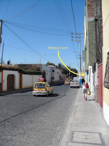
I live on a pretty busy street called Calle Misti, and that’s where I start. I cross the street and turn the corner onto Cuesta del Olivo, which takes me onto a side street that looks like every other one in Yanahaura:

Cuesta del Olivo and one of many stray dogs.

The archway at the end of the street is where I walk through to get into the Plaza de Yanahuara. Most of the streets in Yanahuara look like this, one-lane roads with cobblestone paving that taxis and personal cars get into face-offs over who is going to back out to let the other pass.

Image

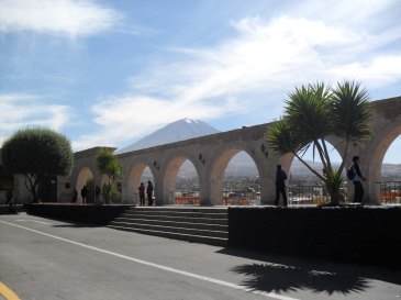
Mirador de Yanahuara, El Misti in the background.

I come into the Plaza de Yanahuara through the far left arch of the mirador (lookout). The arches—and many of the older buildings in Arequipa—are made from the local white volcanic stone called sillar, which gives Arequipa its nickname of “The White City”.

Image

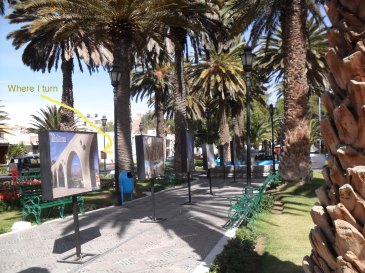
Eastern half of the Plaza de Yanahuara.

The Plaza de Yanahuara is so pretty, and there is ALWAYS something going on. I’ll go more into the plaza later, this post would be really long if I tried to address everything. It is divided into two halves, separated by a street. I cross through the eastern half which is right next to the mirador, and turn left onto Calle Lima between two queso helado (cheese ice cream) vendors dressed into traditional skirts and blouses who have rival carts on opposite corners.

Image

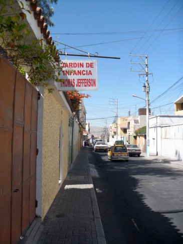
Kindergarten on Calle Lima.

This kindergarten is more than halfway down my walk of Calle Lima, but it’s a pleasant part of the walk since I get to see cute little niños in matching uniforms and hats being dropped off at school by their parents. This one brother and sister pair always make sure to say, “¡Hola! ¡Buenos días!” to me and wave with big silly grins.

Image

Work!

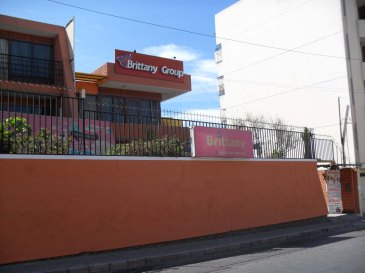
Less than ten minutes after leaving my house, I arrive at Brittany where I have to change out of my battered, ancient Rainbows sandals and into my professional shoes. I had to buy shoes from a Peruvian version of Payless called Bata, but it turns out Peruvians don’t have half-size shoes. So I had the option of shoes that are so small they hurt my toes, or so big they fall off when I walk. So I walk in sandals, and work in shoes. Everyone seems to find this very funny both at my work and on the street, which is why I look forward Casual Fridays when I get to wear sandals in class.